Japan Gold Further Expands Barrick Alliance Projects in Southern Kyushu Following Positive Work Program Results
Vancouver, British Columbia--(Newsfile Corp. - January 26, 2021) - Japan Gold Corp. (TSXV: JG) (OTCQB: JGLDF) (the "Company") is pleased to announce acceptance by the Japanese Ministry of Economy, Trade and Industry ("METI") of 18 new prospecting rights applications covering extensions to the Barrick Alliance, Mizobe and Onoyama-Yamagano Projects in the Hokusatsu Region of the Southern Kyushu Epithermal Gold Province.
Highlights:
- The Hokusatsu Region of Southern Kyushu is Japan's largest gold producing area with low-sulphidation epithermal deposits recording a combined production of over 11 million ounces.
- The 18 new prospecting rights applications accepted by METI bring the Company's total coverage in the Hokusatsu Region to a total of 100,452.8 hectares, approximately 84% of prospective and explorable ground within the region, Figure 1.
- Epithermal vein deposits in the Hokusatsu Region are generally hosted on the western margins of gravity anomalies which form the basis for the new prospecting rights applications.
- The Onoyama-Yamagano Project is located along the prospective Hokusatsu volcanic front, north of the Company's Ohra-Takamine Project and the Barrick Alliance Mizobe-Onoyama Project, and west of the historic Yamagano Gold Mine which produced in excess of 910,000 ounces of gold at a grade of 17.4g/t1
- 9 new applications on the western side of the Onoyama-Yamagano Project were lodged to cover the western flank of a gravity-high feature which has been further defined by the Barrick Alliance project scale geophysical surveys, Figure 2.
- The Mizobe Project, which now incorporates the Mizobe 1st Extension Project, is located in the southeast corner of the Hokusatsu Region and covers an area of gold-antimony anomalism associated with an extensive gravity-high feature that runs through the Mizobe Project and into the northeast part of the Ohra-Takamine Project.
- The 9 new Mizobe West Extension applications were similarly positioned to cover the southwest flanks of the gravity anomaly which coincident with highly anomalous quartz veins, breccia, and sinter floats sampled in drainages on the western side of the Mizobe Project and the southwest portion of the Mizobe-Onoyama Project, Figure 3.
- The Company's portfolio now comprises of 202,926.2 hectares (2029.26 square kilometers) of prospective ground across Japan's 5 major epithermal gold provinces within the three main islands of Kyushu, Honshu and Hokkaido
Hokusatsu Region, Southern Kyushu Epithermal Gold Province
The Hokusatsu Region lies within the northern half of the Southern Kyushu Epithermal Gold Province and covers an area of approximately 120,000 hectares. Hokusatsu is Japan's largest gold producing region with low-sulphidation epithermal deposits recording a combined production in excess of 11 million ounces1,2,3.
Gold mineralization in the Hokusatsu Region is localised along an 80-kilometer long, arcuate, northeast to northerly trending volcanic front west of the Kagoshima graben, and bound by the Kushikino Mine in the west and the Fuke Mine in the north. Low-sulphidation epithermal deposits in the region are characterised by distinctive Bouguer gravity-high anomalies and gradients related to doming of the underlying Cretaceous basement. The Company has utilised this key feature, among others, to expand its comprehensive coverage over the highly prospective Hokusatsu Region.
Onoyama-Yamagano Project
The Onoyama-Yamagano Project is located along the Hokusatsu volcanic front north of the Company's Ohra-Takamine and Barrick Alliance Mizobe-Onoyama Projects, and south of the historic Yamagano Gold Mine which produced in excess of 910,000 ounces of gold at a grade of 17.4g/t1, Figure 1. The Yamagano vein system straddles a significant gravity-high feature and has an approximately 400 year history of underground mining. Project scale gravity surveying completed by the Barrick Alliance has defined an area of gravity anomalism approximately 5 kilometers west of the Yamagano Mine, Figure 2. The newly defined gravity anomaly is covered by volcanic rocks which are younger than the host rocks of the Yamagano veins and may therefore cover mineralization related to the gravity feature. The 9 new applications were positioned to fully cover the western flank of this gravity feature as epithermal vein deposits in the region are generally hosted on the western margins of gravity anomalies. With the inclusion of the 9 new applications the Onoyama-Yamagano Project now comprises a total 12,049.4 hectares.
Mizobe Project
The Mizobe Project which collectively includes the Mizobe, Mizobe 1st Extension applications, and the 9 newly accepted Mizobe West 2nd Extension applications now comprises a total area of 7,579.5 hectares. The Mizobe Project is located in the southeast corner of the Hokusatsu Region covering an area of gold and antimony anomalism associated with an extensive gravity-high feature that runs northwest through the Mizobe Project and into the northeast of the Ohra-Takamine Project, Figure 1 & 3. In the eastern part of the Mizobe Project historic mining activities were focused on antimony mineralization at the Semari and Chuzono Mines. Barrick Alliance results reported in a Company news release dated September 30, 2020 discussed strong gold anomalism associated with antimony bearing breccias and banded quartz veins in drainages across the project, indicating exposure of the upper portions of a potentially extensive epithermal system.
Project scale gravity surveying by the Barrick Alliance has further defined the shape of the extensive gravity feature that runs through the Mizobe and in the Mizobe-Onoyama Projects. Gold and pathfinder element anomalous rock float including sinter sampled in drainages on the west of Mizobe, and the southwest the Mizobe-Onoyama Project indicated the need to expand coverage over the southwestern margins of this gravity feature. This has now been achieved with the acceptance of these 9 new applications.
As the Barrick Alliance programs advance, we will continue to expand the portfolio based on the identification of key prospectivity indicators throughout the gold provinces of Japan.
References
1 Watanabe Y, 2005. Late Cenozoic evolution of epithermal gold metallogenic provinces in Kyushu, Japan. Mineralium Deposita (2005) 40: pp 307-323
2Sumitomo Metal Mining Co., LTD. website, production as of end of March 2020.
3Garwin, S.G. et al. 2005. Tectonic setting, Geology, and gold and copper mineralization in the Cenozoic magmatic arcs of Southeast Asia and the West Pacific. Economic Geology 100th Anniversary Vol. pp 891-930
Qualified Person
The technical information in this news release has been reviewed and approved by Japan Gold's Vice President of Exploration, Andrew Rowe, BAppSc, FAusIMM, FSEG, who is a Qualified Person as defined by National Instrument 43-101.
On behalf of the Board of Japan Gold Corp.
"John Proust"
Chairman & CEO
About Japan Gold Corp.
Japan Gold Corp. is a Canadian mineral exploration company focused solely on gold exploration across the three largest islands of Japan: Hokkaido, Honshu and Kyushu. The Company has a country-wide alliance with Barrick Gold Corporation to jointly explore, develop and mine certain gold mineral properties and mining projects. The Company holds a portfolio of 31 gold projects which cover areas with known gold occurrences, a history of mining and are prospective for high-grade epithermal gold mineralization. Japan Gold's leadership team represent decades of resource industry and business experience, and the Company has recruited geologists, drillers and technical advisors with experience exploring and operating in Japan. More information is available at www.japangold.com or by email at This email address is being protected from spambots. You need JavaScript enabled to view it.
For further information, please contact:
John Proust
Chairman & CEO
Phone: 778-725-1491
Email: This email address is being protected from spambots. You need JavaScript enabled to view it.
Cautionary Note
Neither the TSX Venture Exchange nor its Regulation Services Provider (as such term is defined in the policies of the TSX Venture Exchange) accepts responsibility for the adequacy or accuracy of this release. This news release contains forward-looking statements relating to expected or anticipated future events and anticipated results related to future partnerships and the Company's 2020 gold exploration program. These statements are forward-looking in nature and, as a result, are subject to certain risks and uncertainties that include, but are not limited to, general economic, market and business conditions; competition for qualified staff; the regulatory process and actions; technical issues; new legislation; potential delays or changes in plans; working in a new political jurisdiction; results of exploration; the timing and granting of prospecting rights; the Company's ability to execute and implement future plans, arrange or conclude a joint-venture or partnership; and the occurrence of unexpected events. Actual results achieved may differ from the information provided herein and, consequently, readers are advised not to place undue reliance on forward-looking information. The forward-looking information contained herein speaks only as of the date of this News Release. The Company disclaims any intention or obligation to update or revise forward‐looking information or to explain any material difference between such and subsequent actual events, except as required by applicable laws.
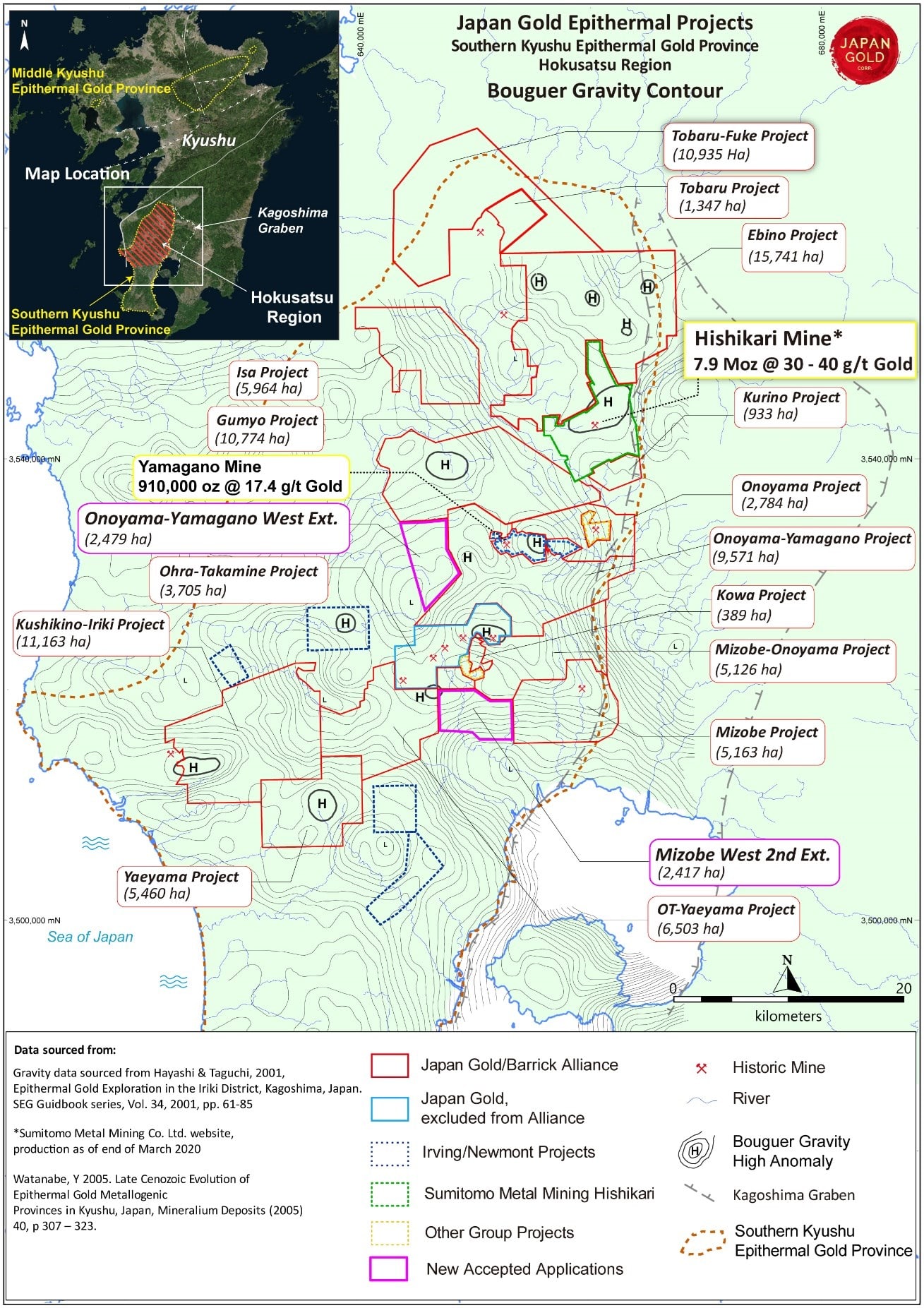
Figure 1: Japan Gold and Barrick Alliance project portfolio with contoured government gravity data, Hokusatsu Region of the Southern Kyushu Epithermal Gold Province
To view an enhanced version of this graphic, please visit:
https://orders.newsfilecorp.com/files/5665/72860_31091c2204cc0ab0_001full.jpg
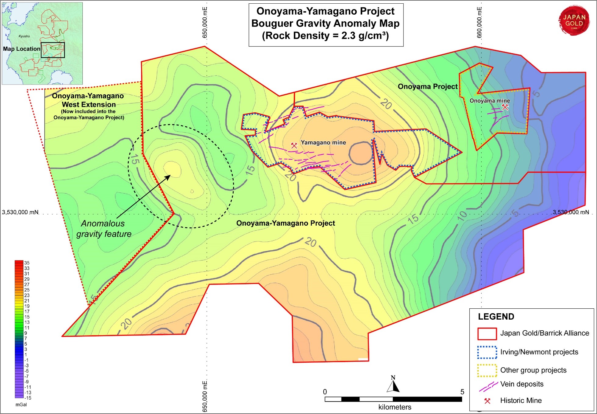
Figure 2: Onoyama-Yamagano Project and new west extension application area on Bouguer gravity contour map
To view an enhanced version of this graphic, please visit:
https://orders.newsfilecorp.com/files/5665/72860_31091c2204cc0ab0_002full.jpg
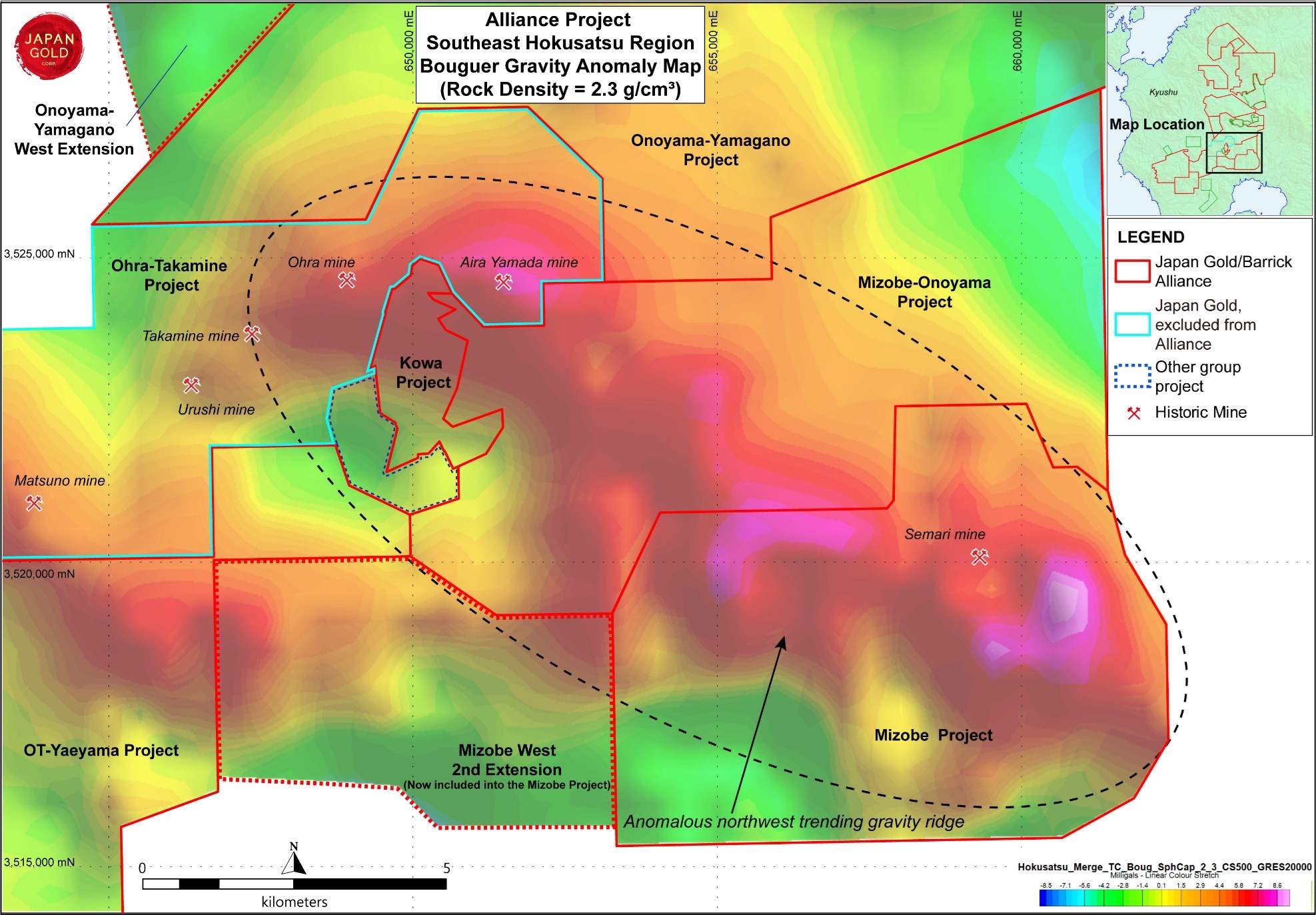
Figure 3: Barrick Alliance Projects southeast Hokusatsu Region on Bouguer gravity contour map
To view an enhanced version of this graphic, please visit:
https://orders.newsfilecorp.com/files/5665/72860_31091c2204cc0ab0_003full.jpg
![]()
To view the source version of this press release, please visit https://www.newsfilecorp.com/release/72860