Exploration
The Company to date has conducted literature reviews and data compilation along with its own geological mapping and sampling campaigns. Recent prospect evaluation work in Q1 2020 has comprised:
- Grid-based B/C horizon soil sampling over a4 km long, and 3.3 km wide sample grid covering the Ohra-Takamine-Urushi area. Composite soil samples were collected at 50 m spacings along 33 individual, north-south orientated grid lines, located 200 m apart. Multi-element geochemical assay and clay spectral analysis were completed on both composite soil samples and accompanying rock-chip samples. Geological and alteration mapping completed in parallel with the soil sampling program has also been compiled and merged with the data set. Soil results confirm the presence of gold and silver in soil anomalism (5 defined areas) across and around the known historical Ohra, Takamine and Urushi mine workings. Anomalous gold in soil along the mine corridor correlates well with elevated levels of the important pathfinder elements, antimony and arsenic. Collectively, gold, silver, mercury, antimony and arsenic provide excellent vectors to lesser explored and understood, high-level alteration zones present to the north and south, and along strike, of the mine corridor. Overall spectral alteration mapping shows a smectite-clay halo following the vein/mineralization trend, and also mutually supports soil anomalism northeast of Ohra and to the north-northwest of Takamine. To the southwest of Urushi younger cover rocks prevail, but continuity of alteration is also apparent.
- A 35 line-kilometer, grid-based, CSAMT geophysical survey was completed along a 4.2 kilometer portion of the Ohra-Takamine Mine corridor. The CSAMT geophysical survey was undertaken to identify zones of sub-surface electrical resistivity and conductivity, representing silicification and clay alteration related to epithermal vein systems. Results of the CSAMT survey are encouraging having defined a number of linear kilometric-scale, contiguous resistive zones (CSAMT anomalies), locally extending to depth across the survey area.
- Bouguer gravity data collected by Haines Surveys Pty Ltd, over an approximate 8 by 4 km area, was merged with regional Geological Survey of Japan gravity data. Fathom Geophysics re-processed the merged data set to enhance rapid changes in gravity gradient. The resulting imagery aids in detection of under-cover or deep-seated basement structures not obvious at surface, along with some definition of structural architecture and faulting which allows pathways for hydrothermal fluid flow, and subsequent quartz vein formation. The spatial relationship between gravity highs and the major low-sulphidation epithermal gold deposits in the province is well described in the literature, and uplift or doming of the underlying basement, producing gravity anomalies, is interpreted as a key factor in the development of deep-seated fracture pathways for hydrothermal fluid flow, and subsequent quartz vein development in these mines.
 Ohra-Takamine Gold Project, Soil grid, CSAMT and gravity geophysical survey locations on geology.
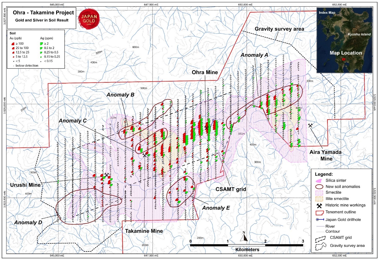 Ohra-Takamine Gold Project, Gold & Silver in soil anomalies with alteration and Structure-Geochem coincident anomalies
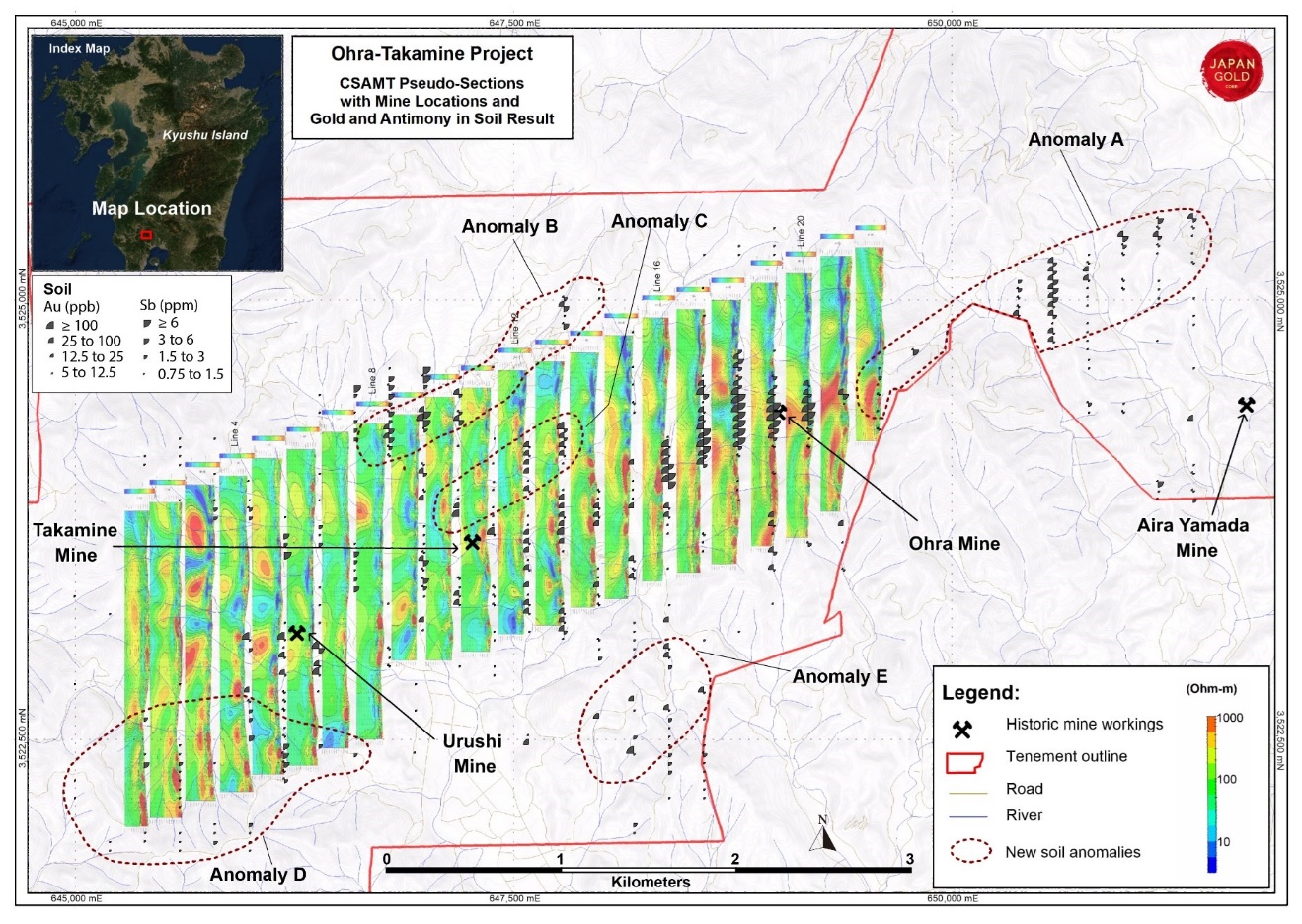 Ohra-Takamine Gold Project, CSAMT stacked pseudo-sections with mine locations and gold / antimony soil anomalies.
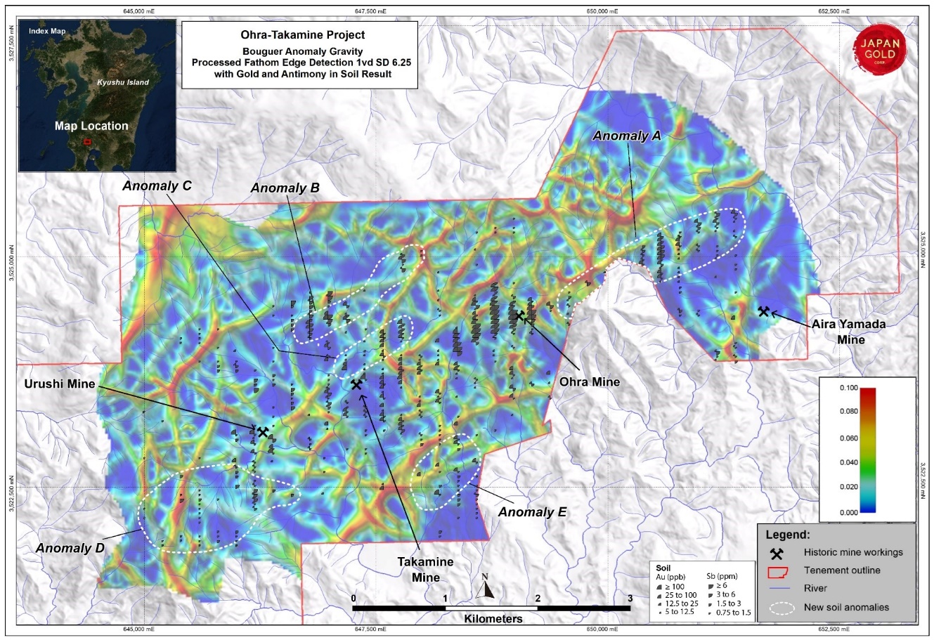 Ohra-Takamine Gold Project, processed gravity with edge detection for structure definition and gold / antimony soil anomalies. Red lines on the gravity image represent contoured gravity gradients and define linear features interpreted to represent basement off-sets and major structures
Phase 1 Drill Program
Only one single (OTD001) and one incomplete (OTD002) Phase 1 scout drillholes totaling 489.3m were completed in Q3 2019, before a management decision was taken to suspend drill operations and move drill crews to Ikutahara in order to complete the 2019 Kitano-o drill campaign before the onset of winter conditions.
Coincident northeast trending gold soil anomalies with other pathfinder elements have been identified overlying contiguous linear zones of high CSAMT resistivity at the Ohra-Takamine Project. Japan Gold is targeting its forthcoming drilling program based on integration of these geochemical, geophysical and geological datasets. Drilling will target defined extensions and parallel vein shoots below and along strike of shallowly developed mine workings and also further along the alteration corridor.
Ohra-Takamine Central Mine Corridor Scout Drill Program
Three scout holes were drilled (total 1624.0 metres (m)) along the central 3.5 kilometres (km) corridor of alteration and epithermal-gold mineralization defined by the Ohra, Takamine and Urushi historic mines. Drilling encountered narrow high-grade gold vein intercepts below the Urushi Mine, and multiple gold-anomalous sheeted quartz vein zones below the Ohra Mine workings (see March 16, 2021 news release for more information).
Information gained from these scout drill holes has been assessed along with coincident anomalies of CSAMT, soil geochemistry, alteration and geological mapping. These results have defined a series of un-tested targets that lie both along strike of, and parallel to the historic mines. The combined strike length of these more coherent geophysical-geochemical-alteration anomalies represents a series of priority drill target areas with a cumulative strike length of over 5 km. A separate, coincident soil geochemical - alteration anomaly extends the Ohra alteration system another 2.5 km along strike to the northeast. Geophysical surveys are planned to further define this large anomaly.
The discovery of new vein zones with limited or weak surface outcrop in the vicinity of the Urushi Mine as well as between the Ohra and Takamine Mines, gives encouragement for the exploration potential both along the trend and below cover further along strike to the southwest, where coincident soil and CSAMT anomalies are partly concealed by younger post-mineral geology.