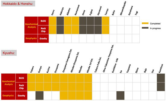
Vancouver, British Columbia--(Newsfile Corp. - October 21, 2020) - Japan Gold Corp. (TSXV: JG) (OTCQB: JGLDF) (the "Company") is pleased to provide a progress report on the Barrick Alliance project activities in the Kitami Metallogenic Province of northeast Hokkaido and the Southern Kyushu Epithermal Gold Province. The current evaluation status of all Barrick Alliance Projects is summarized in the Barrick Alliance Progress Snapshot, at the end of this news release.
Barrick Alliance Work Program
Geochemical Sampling
The initial regional assessment program of the 29 Barrick Alliance Projects includes bulk leach extractable gold (BLEG) and rock float geochemical sampling, and geophysical gravity surveying.
Sediment samples are being collected systematically in streams at a predetermined density across all of the project areas. Fine sediments and clay deposited in active stream channels can contain low levels of metals derived from weathering of mineralized outcrops further up-stream. The BLEG analysis allows ultra-low detection of gold, silver, mercury and copper to highlight anomalous stream catchments. A portion of the sediment sample is split off and separately analyzed for gold and a multi-suit of pathfinder elements to confirm the BLEG result and better understand the nature of the source rocks.
Once anomalous catchments are identified, further sediment sampling is carried out upstream along the anomalous drainage to define the point of entry of anomalous metal. Further definition of the mineralized source is then carried out by rock float sampling and/or soil sampling on the slopes above the anomalous drainage.
Gravity Surveying
The Barrick Alliance regional assessment program also includes the collection of gravity data to assist in understanding structural controls favourable to mineralization at both regional and project scales. In addition, sophisticated processing of the gravity data can enhance detection of faults which control gold mineralization and this will support targeting more focussed geophysical surveys such as CSAMT and magnetics, along with subsequent drilling.
Highlights:
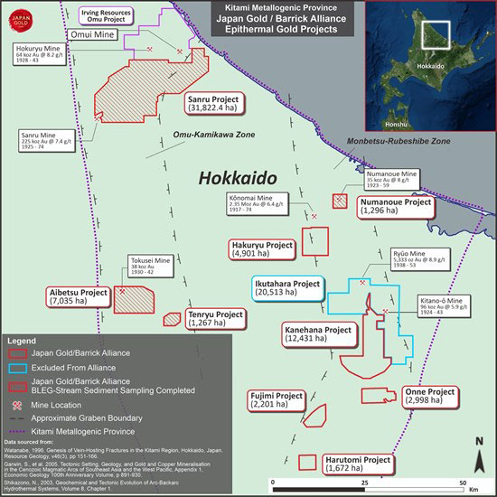
- Geochemical sampling has been completed on 12 out of 29 Barrick Alliance Projects throughout Japan including 4 of 9 Barrick Alliance Projects located in the Kitami Metallogenic Province: Sanru, Aibetsu, Tenryu and Numanoue (Figure 1)
- Geochemical sampling activity has now shifted to the eastern Kitami Region Projects: Hakuryu, Onne, Fujimi and Harutomi (Figure 1)
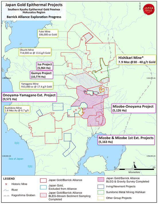
- Geophysical gravity surveying has been completed on 4 out of 14 Barrick Alliance Projects in the Southern Kyushu Epithermal Gold Province: Mizobe, Mizobe 1st Extension, Mizobe-Onoyama and Onoyama-Yamagano (Figure 2)
- Geophysical gravity surveying is currently underway at the Gumyo and Isa Projects (Figure 2)
Exploration Update
Much of the Barrick Alliance work over the past 2 months, in addition to ongoing geophysical surveys in Kyushu, has focussed on the Kitami Region of northeast Hokkaido. The Kitami Metallogenic Province is one of Japan's major epithermal gold provinces with more than 40 historic mines and prospects, including the Konomai Mine, Japan's third largest gold mine (historic production of 2.35Moz at an average grade of 6.4g/t Au)1, the Sanru Mine (historic production of 225,000oz at an average grade of 7.4g/t Au)2 and the Tokusei Mine (historic production of 38,580oz of gold and 472,620oz of silver)3.
Japan Gold has 10 projects with applications and prospecting rights covering 86,135 hectares of prospective ground within the region, 9 of which are included in the Barrick Alliance (65,622.4 hectares) (Figure 1).
Geochemical Sampling
Barrick Alliance field teams completed stream sediment sampling including BLEG analysis as well as rock float sampling across the 31,822.4 hectare Sanru Project on August 29th, with a total of 366 BLEG samples and 151 rock float samples collected. Field activity then moved to the southern end of the Omu-Kamikawa Graben, and the Aibetsu, and Tenryu Projects, which collectively cover 8,301.5 hectares. Sampling of these two project areas has now been completed with a total of 118 BLEG and 139 rock float samples collected across both projects.
Activity has now shifted to the five projects located in the Monbetsu-Rubeshibe Graben, located on eastern side of the Kitami Metallogenic Province. These projects include Hakuryu, Numanoue, Onne, Fujimi and Harutomi, and the recently acquired Kanehana Project, which collectively comprise an area of 31,822 hectares. The eastern Kitami region projects cover numerous historic mines and workings including the southern half of the Konomai Mine vein swarm, Japan's third largest gold mine, which produced 2.35Moz at an average grade of 6.4g/t Au (Figure 1)1. The Barrick Alliance is currently on schedule to complete the first phase of regional stream sampling in Hokkaido before the onset of winter.
Gravity Surveying
Gravity surveying will be completed across all Barrick Alliance projects to further delineate and/or refine regional and project-scale structural and lithological controls, important to the understanding of the controls on epithermal gold mineralization. Gravity surveying is currently progressing well across the southern Kyushu project areas, and is now complete in the Mizobe, Mizobe 1st extension, Mizobe-Onoyama and Onoyama-Yamagano Projects. Gravity surveying is currently on-going across the Gumyo and Isa Projects, and semi-detailed gravity work is scheduled to be completed across all the Alliance Kyushu and Honshu Project areas by the first quarter of 2021, refer to (Figure 2).
About the Aibetsu and Tenryu Projects
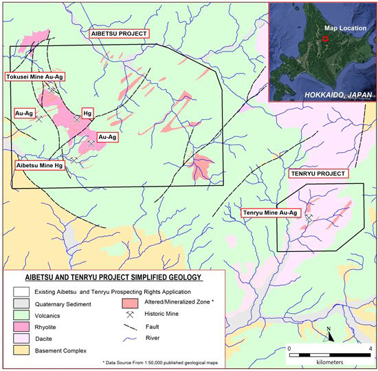
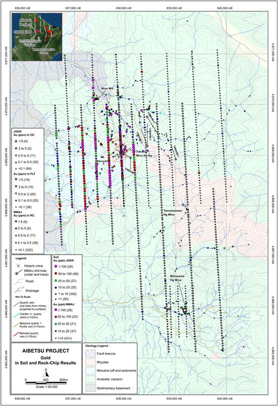
The Aibetsu Project hosts three gold and mercury prospects: the Tokusei gold mine and the Motoyama and Yamamezawa mercury workings, (Figure 3). The historic Tokusei gold mine is reported to have produced 38,580 ounces of gold and 472,620 ounces of silver between 1930 and 1943, from a swarm of 22 sub-parallel, northeast trending epithermal veins. The largest of the veins in the Tokusei mine, the Sanjin-hi vein, is reported to have an average width of 6.4 meters and grades averaging 17.7g/t gold and 20.4g/t silver 3.
Government funded work between 1999 and 2002, included a drill hole intercept of 1.4 meter @ 69g/t Au and 263g/t Ag (468.1-469.5mdh) from a shallowly inclined (40º) hole collared 500m to the northeast of the Tokusei mine workings3. Recent mapping and soil sampling completed at Aibetsu by Japan Gold in 2017, confirmed the presence of high-grade gold mineralization in and around the Tokusei deposit area, and extended the area of geochemical anomalism, (Figure 4). The work not only emphasizes the potential for extensions to the known epithermal vein system at Tokusei, but highlighted the potential for concealed systems below mercury, and other pathfinder element, anomalies located to the northeast, southeast and south of the Tokusei mine.
The Tenryu Project, located three kilometers southeast of Aibetsu contains a similar geological setting and style of veining to that present within the Aibetsu Project area, (Figure 3). Three, sub-parallel, northeast-trending altered-mineralized zones covering a 2.5 by 2 kilometer footprint are located in the middle of the project and includes an underground adit developed along a metres-wide, quartz vein zone which extends below a prominent northeast-trending ridge. A cyanide gold plant that existed four kilometers downstream of the adit, is believed to have processed ore from Tenryu and other workings in the vicinity prior to their closure in 1943.
About the Hakuryu Project
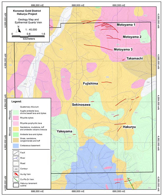
The Hakuryu Project covers the southern half of the Konomai Mine district, and is located 20 kilometers northwest of the Ikutahara and Kanehana Projects, (Figure 1 & 5). The Konomai Mine was Sumitomo Mining Metals Corp's first gold asset, with production of 2.35 million ounces of gold at an average grade of 6.4g/t and 40 million ounces of silver from approximately 20 veins, prior to mine closure in 19734.
Two of the Konomai Mine's major veins, Motoyama and Fujishima, which collectively produced more than 770,000 ounces of gold and 7.6 million ounces of silver4,5, are located in the northern half of the Hakuryu Project area, refer to (Figure 5). Systematic exploration of the Hakuryu Project did not commence south of Motoyama until 1952, following construction of a road built to link the towns of Omu and Engaru. Road access into this formally remote part of the Konomai vein field lead to the discovery of the Fujishima stockwork vein system in 1955, 40 years after the discovery of the first vein at Konomai in 19155. The details and extent of modern exploration completed by Sumitomo south of Motoyama following road construction and prior to mine closure in 1973, within the southern part of the Konomai vein field remains unclear. This short window of exploration activity coupled with the fact that the Fujishima ore-body is blind and located below extensive, sub-horizontal, silica-rich capping which overlie large portions of the project area, indicate there is significant exploration potential for the discovery of further epithermal veins within the Hakuryu Project.
About the Numanoue Project
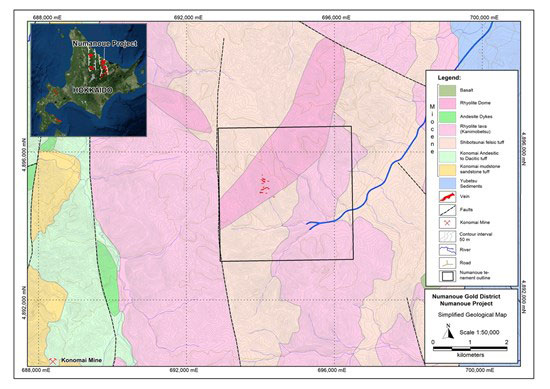
The Numanoue Project is located seven kilometers northeast of the Konomai gold-silver District and is inferred to represent an en-echelon extension to the vein systems located in the northern half of the Konomai field. The historic Numanoue mine (1923-59), which produced 35,365 ounces of gold and 2.6 million ounces of silver at an average grade of 8.0g/t gold and 815g/t silver6, is located in the middle of the Numanoue Project area hosted within an elongate, northeast-trending rhyolite intrusion, 5 by 1km in dimension, refer to Figure 6.
The Numanoue epithermal system comprises a minimum of 12 steeply inclined veins that vary in orientation between a west-northwest to east-northeast strike. Mineralized structures are up to 400m in lateral extent (e.g. the Matsu-hi vein) and mining occurred to a maximum depth of 150m. Vein widths in historical workings range from 0.2 to 4.5m thickness, and gold-silver values from past-production vary between 2.7 to 17.0 g/t gold and 15 to 1,500 g/t Ag6.
Exploration conducted by the MMAJ in the early 1990's defined coincident gold-arsenic-antimony in soil anomalies along strike to the northeast of the historic mine, some coincident with induced polarisation geophysical anomalies. One of these anomalies tested by a single drill-hole yielded an intersection of 9m @ 0.3g/t gold from 186 metres downhole associated with the contact of a vertical andesite dyke6. No modern exploration has occurred within the project area since this work.
Barrick Alliance Progress Snapshot
To view an enhanced version of image, please visit:
https://japangold.com/images/news_releases/2020/JapanGold_News_Release_Oct_21_01Full.jpg
References
1 Watanabe, Y., (1995). A Tectonic Model for Epithermal Au Mineralisation in NE Hokkaido, Japan. Resource Geology Special Issue, No. 18, pp. 257-269.
2 METI, 1997-1998. Reports completed by MITI on the Sanru area (Years 9 and 10). The Agency of Natural Resources and Energy of MITI.
3 Metal Mining Agency of Japan (1999-2002), Geological Survey Report for Fiscal Years 1999 through 2002, North Hokkaido Area.
4 Sumitomo Metal Mining Co. Ltd. (Editorial Committee), Oct. 2003. The Konomai Mine History 50th Anniversary - The History of Sumitomo Konomai Gold Mine, p. 59 - 73.
5 Metals Mining Agency Japan (MMAJ), 1990. Nippon Mining Corp (NMC) Survey Report 3, p. 58-64 & 76-79.
6 Metals Mining Agency Japan (MMAJ), 1990. Gold Mines in Japan Vol. 2 - Hokkaido, 'Yellow Book' Publication, p. 46-53.
Qualified Person
The technical information in this news release has been reviewed and approved by Japan Gold's Vice President of Exploration and Country Manager, Andrew Rowe, BAppSc, FAusIMM, FSEG, who is a Qualified Person as defined by National Instrument 43-101.
On behalf of the Board of Japan Gold Corp.
"John Proust"
Chairman & CEO
About Japan Gold Corp.
Japan Gold Corp. is a Canadian mineral exploration company focused solely on gold exploration across the three largest islands of Japan: Hokkaido, Honshu and Kyushu. The Company has a country-wide alliance with Barrick Gold Corporation to jointly explore, develop and mine certain gold mineral properties and mining projects. The Company holds a portfolio of 31 gold projects which cover areas with known gold occurrences, a history of mining and are prospective for high-grade epithermal gold mineralization. Japan Gold's leadership team represent decades of resource industry and business experience, and the Company has recruited geologists, drillers and technical advisors with experience exploring and operating in Japan. More information is available at www.japangold.com or by email at
For further information, please contact:
John Proust
Chairman & CEO
Phone: 778-725-1491
Email:
Cautionary Note
Neither the TSX Venture Exchange nor its Regulation Services Provider (as such term is defined in the policies of the TSX Venture Exchange) accepts responsibility for the adequacy or accuracy of this release. This news release contains forward-looking statements relating to expected or anticipated future events and anticipated results related to future partnerships and the Company's 2020 gold exploration program. These statements are forward-looking in nature and, as a result, are subject to certain risks and uncertainties that include, but are not limited to, general economic, market and business conditions; competition for qualified staff; the regulatory process and actions; technical issues; new legislation; potential delays or changes in plans; working in a new political jurisdiction; results of exploration; the timing and granting of prospecting rights; the Company's ability to execute and implement future plans, arrange or conclude a joint-venture or partnership; and the occurrence of unexpected events. Actual results achieved may differ from the information provided herein and, consequently, readers are advised not to place undue reliance on forward-looking information. The forward-looking information contained herein speaks only as of the date of this News Release. The Company disclaims any intention or obligation to update or revise forward‐looking information or to explain any material difference between such and subsequent actual events, except as required by applicable laws.
Figure 1. Kitami Region, northeast Hokkaido, Barrick Alliance and Japan Gold Projects and significant mines.
To view an enhanced version of Figure 1, please visit:
https://japangold.com/images/news_releases/2020/JapanGold_News_Release_Oct_21_02Full.jpg
Figure 2. Hokusatsu Region, southern Kyushu, Barrick Alliance and Japan Gold Projects and work programs completed to date.
To view an enhanced version of Figure 2, please visit:
https://japangold.com/images/news_releases/2020/JapanGold_News_Release_Oct_21_03Full.jpg
Figure 3. Aibetsu and Tenryu Project simplified geology.
To view an enhanced version of Figure 3, please visit:
https://japangold.com/images/news_releases/2020/JapanGold_News_Release_Oct_21_04Full.jpg
Figure 4. Gold (ppb) in soil and Au (ppm) in rock-chip results across the western half of the Aibetsu Project area and the location of historical mines and workings.
To view an enhanced version of Figure 4, please visit:
https://japangold.com/images/news_releases/2020/JapanGold_News_Release_Oct_21_05Full.jpg
Figure 5. Hakuryu Project application block with major Konomai group vein deposit locations on simplified geology.
To view an enhanced version of Figure 5, please visit:
https://japangold.com/images/news_releases/2020/JapanGold_News_Release_Oct_21_06Full.jpg
Figure 6. Numanoue Project location with simplified geology.
To view an enhanced version of Figure 6, please visit:
https://japangold.com/images/news_releases/2020/JapanGold_News_Release_Oct_21_07Full.jpg

To view the source version of this press release, please visit https://www.newsfilecorp.com/release/66482


