
Commodity
Gold
Target
Low Sulphidation Epithermal Gold
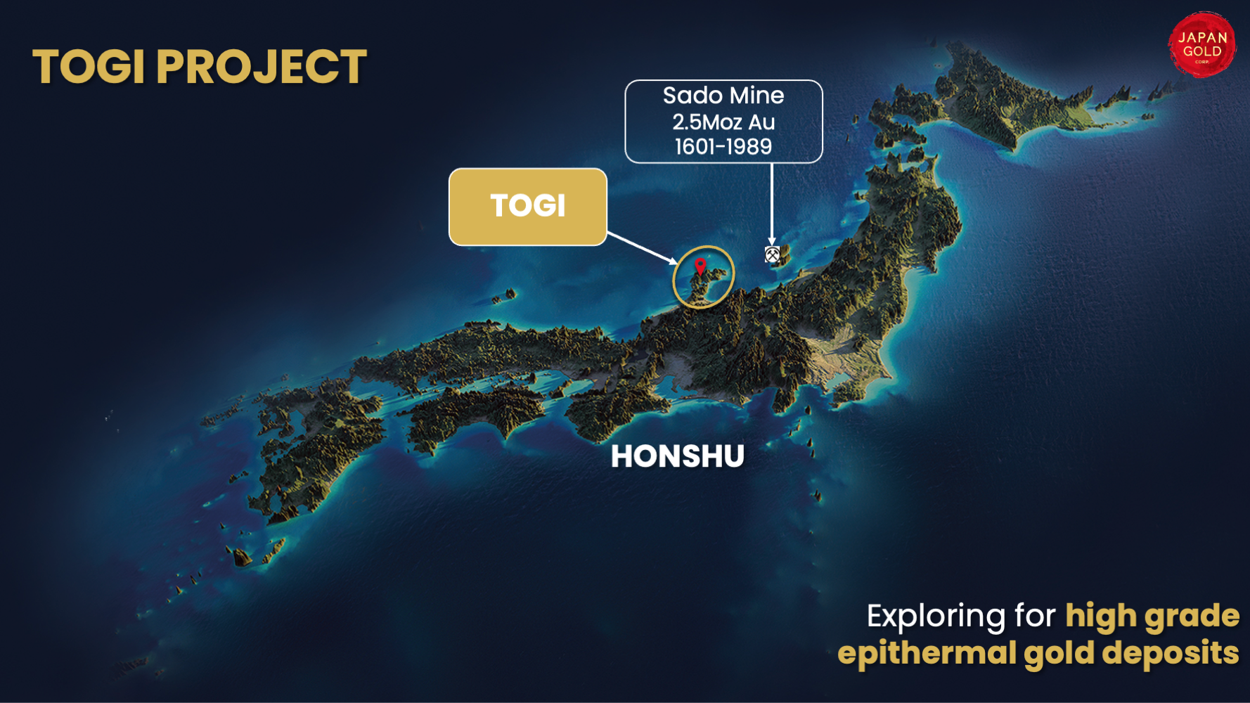
Location
Noto Peninsula, Honshu Island
Exploration Stage
Initial 2-hole drill program completed
Togi Project
The Togi Project is located in the central west part of Honshu Island on the Noto Peninsula, centred on the historic Togi Goldfield. A similarly oriented graben-gravity feature and Miocene host rocks are noted 160km along strike to the northeast on Sado Island, which hosted Japan's second largest gold mine, the Sado Mine, which produced 2.5 million ounces of gold until its closure in 1974.
Gold mineralization was discovered in the Togi area in 1896, and historic records from the Togi Goldfield report seven separate areas of workings along a 7 km trend, which produced a combined 48,000 oz of gold and 180,000 oz of silver between 1910-21.
Togi Goldfield
The Togi Project comprises an area of 3,990 hectares covering the Togi Goldfield which includes the Urugami and Hirochi areas of workings. Deposits mined in the project area are divided into the Hirochi deposits in the northeast and Urugami deposits in the southwest.
The Mori vein from the Hirochi group at the northeast end of the corridor produced 16,500 oz and was reported to be up to 4 m wide with production grades averaging 14 g/t gold. Records show mineralization in lower mine levels appear open to depth with average grades of 8.12 g/t gold and 56.9 g/t silver (Source: Gold Mines of Japan, 1989. The Mining & Materials Processing Institute of Japan).
In the southwest area of the Togi Goldfield, historic mine workings on the Urugami deposits cover over 30 small veins and stockwork zones within a two-by-two-kilometre zone. The Togo Mine, the largest within the Urugami area, produced over 18,000 oz of gold and 83,000 oz of silver from stockwork vein and breccia zones (Sources: Gold Mines of Japan, 1989. The Mining & Materials Processing Institute of Japan; Austpac Gold NL., 1988-94. Company Annual Reports).
Gold and silver mineralisation from the Urugami veins in the southwest of the corridor are hosted in stockwork vein and breccia zones. Mapped Sinter and the narrower stock-work style of quartz vein mineralization at Urugami indicate the top of a hot-spring epithermal system is preserved, supporting the potential for deeper boiling-zone vein targets in this area.
Historic exploration and drilling results
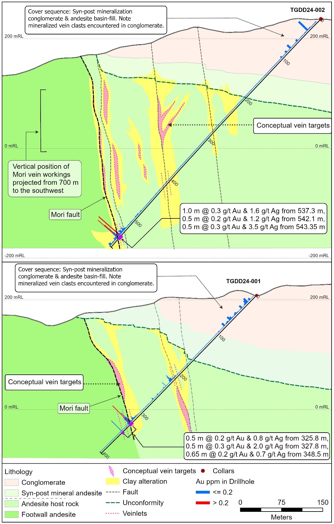
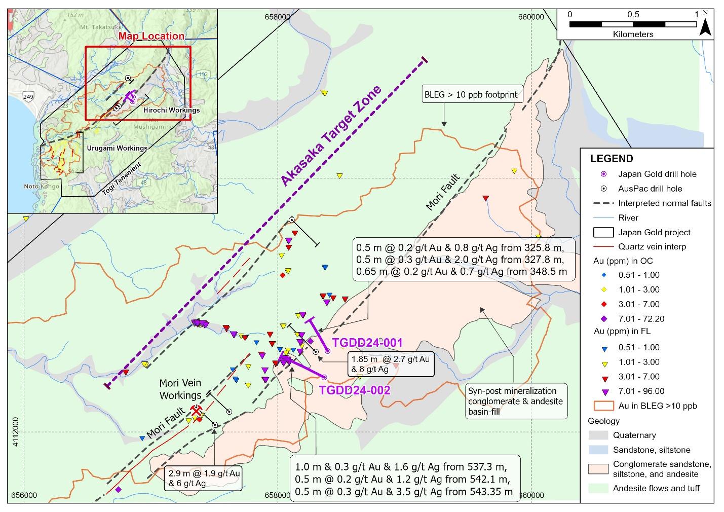
In 1988 the NICAM joint-venture between the Nissho-Iwai Corporation and Austpac Gold NL undertook exploration in the Togi Goldfield. Work completed included mapping, rock and soil sampling, and CSAMT surveys and included four diamond drill holes in 1990. A summary of this work is included in Figure 2 with gold in rock values, alteration mapping and the 1990 drill hole locations and intercepts. Drilling intercepted anomalous gold values including an 11.3 metre interval of silicification and brecciation averaging 0.45 g/t gold, including 1.85m @ 2.72 g/t gold from 335.6 meters downhole (Source: Austpac Gold NL., 1988-94. Company Annual Reports). The four reported drill holes are anomalous and encouraging but have insufficiently tested the seven-kilometre corridor.
Areas of intense clay alteration seen along road cuts between the Hirochi and Urugami deposits suggest continuity of the hydrothermal system between the two main deposit groups, and along the seven kilometre structural trend (Source: Austpac Gold NL., 1988-94. Company Annual Reports), further emphasizing exploration potential.

Togi Goldfield Project showing clay alteration zones, historic workings and NICAM JV compilation.
- Mori Vein - strike extensions of the Mori vein obscured by post mineralisation cover.
- Initial 1,000-meter 2-hole drill program was completed to test the Akasaka target.
Drilling at the Togi Project - Akasaka target increased confidence in extensions to a concealed and well-preserved low-sulfidation gold system, extending a kilometer from known workings and with strike potential of an additional 2 kilometers.
An initial two drill holes were completed at the Akasaka target in November 2024 targeting concealed strike extensions of the Mori vein where historical workings produced 16,500 oz of gold at an average grade of 14 g/t Au. The two drill holes located 700 metres along strike of the Mori workings and spaced 350 metres apart targeted vein extensions below concentrations of sinter scree, and quartz vein boulders and cobbles hosting gold grades up to 79.7 g/t gold, refer to Figure 1.
Drilling intersected parallel alteration zones representing inferred structural extensions of the Mori fault and Mori vein hanging-wall structures concealed by up to 140 metres of syn to post mineralization andesite and conglomerate. Alteration intersected hosts low-temperature clay assemblages and spaced narrow opaline to chalcedonic-carbonate-sulphide veins anomalous in pathfinder elements including gold. The Mori Fault zone intersected in the lower sections of both drill holes is also anomalous in gold, hosting breccia clasts of quartz-carbonate vein indicating the fault was actively moving during mineralization providing the potential for dynamic boiling levels and faulting, refer to Figure 2 and Tables 1 and 2.
Table 1: Significant Mineralized Intercepts
| Drill Hole ID | From (m) | To (m) | Length (m) | Au (ppm) | Ag (ppm) |
|---|---|---|---|---|---|
| TGDD-24-001 | 325.80 | 326.30 | 0.50 | 0.2 | 0.8 |
| TGDD-24-001 | 327.80 | 328.30 | 0.50 | 0.3 | 2.0 |
| TGDD-24-001 | 348.50 | 349.15 | 0.65 | 0.2 | 0.7 |
| TGDD-24-002 | 537.30 | 538.30 | 1.00 | 0.3 | 1.6 |
| TGDD-24-002 | 542.10 | 542.60 | 0.50 | 0.2 | 1.2 |
| TGDD-24-002 | 543.35 | 543.85 | 0.50 | 0.3 | 3.5 |
Table 2: Drill Hole Data
| Drill Hole Number | Location | Easting | Northing | RL (m) | Azimuth ° | Dip° | Length (m) |
|---|---|---|---|---|---|---|---|
| TGDD24-001 | Akasaka | 658394.0 | 4112638.0 | 197.2 | 330 | 45 | 403.5 |
| TGDD24-002 | Akasaka | 658368.0 | 4112431.0 | 224.1 | 295 | 45 | 564.7 |
Figure 1: Togi Project, simplified geological map of the Akasaka target area within the Togi Goldfield with drill hole summaries, rock geochemistry and >10 ppb BLEG footprint.
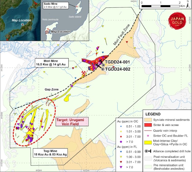
Figure 2: Drill hole sections for TGDD-001 and 002 with interpreted geology and significant intercepts.